By Tatiana Rodriguez
The Chamizal neighborhood is one of the oldest in El Paso. It "is bounded to the north by Alameda Avenue, the east by Gateway South Boulevard, the south by Paisano Drive and the Cesar Chavez Memorial Highway, and the west by Laurel Street."1 Chamizal got its name from the chamizo plant, the four-wing saltbush.2 This bush grew copiously in this neighborhood, land in the floodplain disputed between the U.S. and Mexico. The Chamizal dispute began in 1864 when flooding pushed the Rio Grande south into Ciudad Juárez, formerly known as Paso del Norte. Across the river, El Paso residents were relocated to El Chamizal. Jurisdiction of El Chamizal was questioned, leading to a century of dispute.
During the 1890s, the Rio Grande made a bend east of downtown El Paso. At the time, the international boundary remained along the river's deepest channel. The Rio Grande's change in course left a piece of Mexican land jutting into U.S. territory, known as Cordova Island.3 In 1940, Mexico built a fence along the perimeter. Some concrete fence posts remain along the Chamizal National Memorial's northwest corner.
Eventually, in July 1963, U.S. and Mexican negotiators reached an agreement. Mexican Secretary of Foreign Relations Manuel Tello and U.S. Ambassador Thomas C. Mann signed the Chamizal Convention of 1963 in Mexico City. To settle the dispute, the U.S. government bought private and commercial properties to exchange land with Mexico. About 5600 residents of El Paso neighborhoods, including Rio Linda and Cordova Gardens were required to relocate. "Property owners received at least fair market value and were compensated for moving."4 The following year, in 1964, Presidents Adolfo Lopez Mateos and Lyndon B. Johnson shook hands during the ceremony to commemorate the ratification and signing of the Chamizal Convention.5 The ceremony was held on the former grounds of Bowie High School (today Guillen Middle School). Bowie High lost some of its ground during the enactment of the Chamizal Convention.
On October 28, 1967, the U.S. and Mexico officially marked the exchange of land that ended the Chamizal dispute.6 On December 13, 1968, Presidents Gustavo Díaz Ordaz, who succeeded Lopez Mateos and Johnson pushed the buttons on a box to open the Adolfo Lopez Mateos River Channel that formed the new U.S.-Mexico boundary. They then bid each other farewell on the recently constructed Bridge of the Americas after three days of celebration in El Paso-Ciudad Juarez and Washington, D.C.
Today, the Chamizal neighborhood faces health and safety issues. In May 2024, Familias Unidas del Chamizal held a press conference at city hall to speak about the concerns they have in their community. Spokesperson for Familias Unidas del Chamizal, Hilda Villegas said their community is surrounded by multiple sources of pollution such as the diesel trucks that pass through the Bridge of Americas and the recycling facility at Paisano Drive and Coles Street that caught fire in late May of this year.7 It took 200 firefighters to extinguish the fire, and it is one of the largest fires in El Paso history.

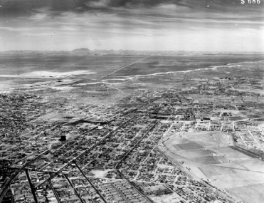


Left Image: Historic Aerial Photo of Chamizal, 1950. City of El Paso Community Development. https://www.elpasotexas.gov/assets/Documents/CoEP/Community-Development/Neighborhood-Associations/Neighborhood-Revitalization/CHAMIZAL-NRS.pdf.
Right Image: Historic photo of the International Boundary of U.S. and Mexico at Cordova Island, 1930s. National Park Service. https://www.nps.gov/cham/learn/historyculture/conflict.htm.
Footnotes:
1 City of El Paso Community Development, "Chamizal Neighborhood Revitalization Strategy," January 2008.
2 National Park Service, "Water Made this Place," https://www.nps.gov/cham/learn/historyculture/cultural-landscape.htm.
3 National Park Service, "Century of Conflict," https://www.nps.gov/cham/learn/historyculture/conflict.htm.
4 National Park Service, "Implementation," https://www.nps.gov/cham/learn/historyculture/implementation.htm.
5 National Park Service, "Celebration," https://www.nps.gov/cham/learn/historyculture/celebration.htm.
6 Ibid.
ความคิดเห็น