By Jacqueline Sierra
The boundary between the United States and Mexico has always been a point of contention between the two nations. In the aftermath of the U.S.-Mexico War (1846-1848), the Treaty of Guadalupe Hidalgo (1848) gave half of Mexico's land to the United States, and made the Rio Grande the official boundary between the two countries. However, this free-flowing river is a natural boundary that is destined to change over time due to the erosion of the riverbanks. Because of this, the Rio Grande "stood at the center of an international boundary dispute [for] nearly a century," and the resolutions to this issue affected hundreds of people on both sides of the border.
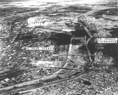
In the mid-19th century, a private property dispute between the settlements in El Paso, Texas and Ciudad Juárez, Mexico sparked the years long feud over where the boundary between the two countries was meant to lay. Starting in 1895, Mexico made claims on the section of land that came to be known as the Chamizal. The United States made a rebuttal by also making claims on this section of land, thus beginning years of tension between the two countries. This then caused years of negotiations between the leaders of the U.S. and Mexico.
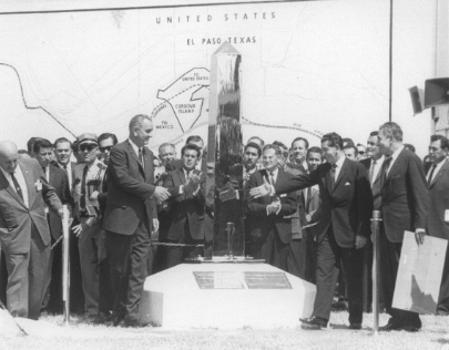
This issue was not settled until 1962 when U.S. President John F. Kennedy and Mexican President Adolfo Lopez Mateos agreed to build a permanent concrete channel for the Rio Grande. The new channel would split the disputed land in half. All land north of the channel would belong to the U.S. and all land south would belong to Mexico. Sadly, President Kennedy's assassination halted the completion of the project, and President Lyndon B. Johnson finalized the concluding negotiations with the Chamizal Treaty of 1963. The new channel took five years to complete, and water was finally diverted to into the channel.2 The land given to the U.S. became the Chamizal National Memorial.3
The agreement to build the concrete channel also meant that those living near the Rio Grande would have to be relocated. In 1994, the University of Texas at El Paso's Institute of Oral History conducted an interview with J. Samuel Moore, an attorney who worked with the law firm associated with the Chamizal arbitration. Moore stated that both of the U.S. and Mexican sides of the border near the construction were "heavily populated," made up "of residences, commercial buildings, government facilities, and immigration headquarters."4 As a result, all of these buildings were relocated, and all residences were given payouts for their properties to find other living accommodations in El Paso and Ciudad Juárez.
Although Moore claimed no one officially complained about relocation, it is not hard to conceive that this caused intense strain for those affected by the move. In addition, many native communities in this area view the river as incredibly sacred. The construction on the ground the river inhabited was a traumatic event, according to Javier Loera, War Captain of the Ysleta del Sur Pueblo Tribal Council.5 Loera stated, "the river, the Rio Grande, La Perla is a living entity ... it's part of our cultural landscape ... it is very important that [native communities] maintain ties to the river," in spite of the trauma they have endured.6
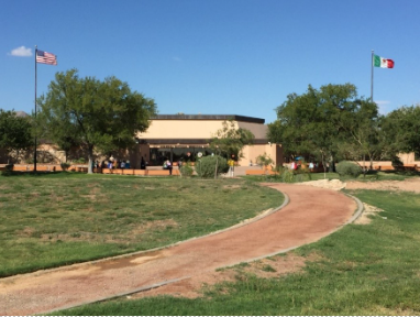
Over the years of the Chamizal's development in the U.S., it has become a site of cultural preservation for the El Paso community. Many people gather here to celebrate their Mexican and Mexican American identities by taking part in Viva El Paso, a play that tells the histories of El Paso and Mexico through song and dance, and other cultural heritage groups working to preserve these two cities' rich histories.7


Footnotes:
1 Photo courtesy of Radio Diaries The Chamizal: A Town Between Borders - Radio Diaries
2 “Conflict | Resolution.” National Parks Service. U.S. Department of the Interior, December 23, 2021. https://www.nps.gov/cham/learn/historyculture/conflict-resolution.htm.
3 Photo Courtesy of “The Chamizal: A Town between Borders.” Radio Diaries, October 18, 2016. https://www.radiodiaries.org/the-chamizal/.
4 Interview 842
5 “Conflict | Resolution.” National Parks Service. U.S. Department of the Interior, December 23, 2021. https://www.nps.gov/cham/learn/historyculture/conflict-resolution.htm.
6 Ibid.
7“Kaleidoscope Weekend” The El Paso Times. April 27th, 1979. Photo courtesy of “Conflict | Resolution.” National Parks Service. U.S. Department of the Interior, December 23, 2021. https://www.nps.gov/cham/learn/historyculture/conflict-resolution.htm.
References:
“Chamizal Project Office Opens” The El Paso Times. September 8th, 1967.
“Conflict | Resolution.” National Parks Service. U.S. Department of the Interior, December 23,
Foster, Bud. “Park Historian Begins Research for Chamizal Memorial Exhibits.” The El Paso
Times. February 4th, 1968.
Gomilla, Michelle. Interview no. 842 of J. Samuel Moore. Institute of Oral History at The
University of Texas at El Paso. April 27th, 1994.
Hail, Marshall. “Chamizal Plan Gives E.P. Opportunity for New Border Personality.” El Paso
Herald Post. September 22nd, 1965.
“Here’s Chamizal Memorial Plan.” El Paso Herald Post. July 14th, 1966.
“Kaleidoscope Weekend” The El Paso Times. April 27th, 1979.
“More Than 60 Events Planned for Fiesta Chamizal; Opening Sept. 28” The El Paso Times.
September 13th, 1968.
Morgan, Hugh. “Chamizal Resident Lonely.” The El Paso Times. April 22nd, 1966.
Santoyo, Maribel. “’Viva Mexico’”. The El Paso Times. September 24th, 1999.
“US, Mexico Spend Millions on Chamizal Projects.” El Paso Herald Post. October 27th, 1967.
Ybarra, Rob. “Lack of Funds Curbs Chamizal Memorial Work.” El Paso Herald Post. June 10th, 1969.
Comments